

Application of UAV Environmental Thermography Monitoring Based on Agisoft Metashape Image Mosaic
-
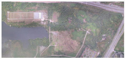
摘要: 为实现大面积区域的环境热像监测,本文以重庆某高校训练场为例,研究了一种无人机区域环境热像监测技术。通过无人机采集环境热像,使用Agisoft Metashape软件进行无人机热红外影像拼接处理,并利用处理后的热红外影像进行环境热像监测与目标分析。研究表明,利用该技术可实现区域热红外影像的快速处理,并且处理成果可以为环境热像监测与目标热像分析提供有效参考与基础资料。
-
关键词:
- Agisoft Metashape /
- 影像拼接 /
- 环境监测 /
- 热像分析
Abstract: To realize environmental thermal image monitoring in a large area, this study took a university training field in Chongqing as an example to investigate UAV regional environmental thermal image monitoring technology. First, the UAV was used for environmental thermal image acquisition, and the Agisoft Metashape software was used for UAV thermal infrared mosaic thermal image processing. The processed thermal infrared images were used for environmental thermal image monitoring and target analysis. Experiments showed that the technology can realize fast processing of regional thermal infrared images, and the processing results can provide an effective reference and basic data for environmental thermal image monitoring and target thermal image analysis.-
Key words:
- Agisoft Metashape /
- image stitching /
- environmental monitoring /
- thermal image analysis
-

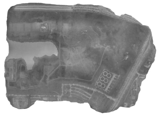
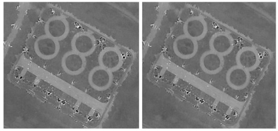
图 8 两种源数据的处理结果无明显差异
Figure 8. There is no obvious difference between the processing results of two source data
表 1 禅思XT2技术参数
Table 1. Technical parameters of XT2
Thermal imaging camera vision camera Resolution 640×512 4K: 3840×2160 FHD: 1920×1080 Focal Length
(mm)19 8 Active Picture Elements — 12 million Wavelength coverage(μm) 7.5-13.5 — Sensitivity
(mk@f/1.0)< 50 —  下载: 导出CSV
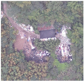
表 2 测温区内各测温点温度信息
Table 2. Temperature information of temperature measuring points
Numbering Object category Temperature sensing point Temperature point display temperature/℃ 1 Gravel soil road SP1 9.3 SP2 9.8 SP3 9.5 2 Bagged domestic waste SP4 10.2 SP5 11.5 SP6 12.2 3 Plant SP7 8.5 SP8 8.8 SP9 8.9 4 White wastes SP10 8.2 SP11 8.0 SP12 8.0 5 Waste roofs SP13 8.1 6 Engineering dustproof net SP14 8.7 SP15 8.3 7 Climax temperature Red temperature point 15.3 8 Lowest temperature point Blue temperature point 5.8
下载: 导出CSV
-
[1] 孙新博, 孙芹芹, 李英成, 等. 无人机红外影像拼接方法研究[J]. 测绘科学, 2021, 46(6): 109-113, 120. https://www.cnki.com.cn/Article/CJFDTOTAL-CHKD202106016.htmSUN Xinbo, SUN Qinqin, LI Yingcheng, et al. Research on UAV infrared image mosaic method [J]. Surveying and Mapping Science, 2021, 46(6): 109-113, 120. https://www.cnki.com.cn/Article/CJFDTOTAL-CHKD202106016.htm [2] 赵国顺. 浅析红外热成像技术的发展与应用[J]. 中国安防, 2016(4): 38-40. https://www.cnki.com.cn/Article/CJFDTOTAL-ZGAF201604013.htmZHAO Guoshun. Analyze the development and application of infrared thermal imaging technology[J]. China Security, 2016(4): 38-40. https://www.cnki.com.cn/Article/CJFDTOTAL-ZGAF201604013.htm [3] 杜静涵. 红外热图像拼接技术的研究与应用[D]. 南京: 南京理工大学, 2017.DU Jinghan. Research and application of infrared thermal image stitching technology[D]. Nanjing: Nanjing University of Science and Technology, 2017. [4] Jebur A, Abed F, Mohammed M. Assessing the performance of commercial Agisoft PhotoScan software to deliver reliable data for accurate3D modelling[J]. MATEC Web of Conferences, 2018, 162: 03022. doi: 10.1051/matecconf/201816203022 [5] Barbasiewicz A, Widerski T, Daliga K. The analysis of the accuracy of spatial models using photogrammetric software: Agisoft Photoscan and Pix4D[J]. E3S Web of Conferences, 2018, 26: 12. doi: 10.1051/e3sconf/20182600012 [6] 代婷婷, 马骏, 徐雁南. 基于Agisoft PhotoScan的无人机影像自动拼接在风景园林规划中的应用[J]. 南京林业大学学报: 自然科学版, 2018, 42(4): 165-170. https://www.cnki.com.cn/Article/CJFDTOTAL-NJLY201804024.htmDAI Tingting, MA Jun, XU Yannan. Application of UAV image automatic stitching based on Agisoft PhotoScan in landscape architecture planning[J]. Journal of Nanjing Forestry University: Natural Science Edition, 2018, 42(4): 165-170. https://www.cnki.com.cn/Article/CJFDTOTAL-NJLY201804024.htm [7] 李秀全, 陈竹安, 张立亭. 基于Agisoft PhotoScan的无人机影像快速拼接在新农村规划中的应用[J]. 湖北农业科学, 2016, 55(3): 743-745. https://www.cnki.com.cn/Article/CJFDTOTAL-HBNY201603051.htmLI Xiuquan, CHEN Zhuan, ZHANG Liting. Application of UAV image rapid stitching based on Agisoft PhotoScan in new rural planning [J]. Hubei Agricultural Science, 2016, 55(3): 743-745. https://www.cnki.com.cn/Article/CJFDTOTAL-HBNY201603051.htm [8] 马代健. 无人机热红外图像采集系统开发与应用[D]. 杨凌: 西北农林科技大学, 2018.MA Daijian. Development and Application of UAV Thermal Infrared Image Acquisition System[D]. Yangling: Northwest A & F University, 2018. [9] 姚俐. 红外全景图像拼接方法的研究[D]. 重庆: 重庆邮电大学, 2020.YAO Li. Research on Infrared Panoramic Image Stitching Method[D]. Chongqing: Chongqing University of Posts and Telecommunications, 2020. [10] LIU Jinsong, DAI Shaosheng, GUO Zhongyuan, et al. An improved POCS super-resolution infrared image reconstruction algorithm based on visual mechanism[J]. Infrared Physics and Technology, 2016, 78: 92-98 doi: 10.1016/j.infrared.2016.07.010 [11] 张晓宇. 基于特征的图像拼接技术研究[D]. 西安: 西安理工大学, 2010.ZHANG Xiaoyu. Research on Feature-Based Image Mosaic Technology [D]. Xi 'an : Xi 'an Polytechnic University, 2010. [12] 邵万里. Agisoft PhotoScan在立面测量中的应用[J]. 城市勘测, 2019(2): 74-76. https://www.cnki.com.cn/Article/CJFDTOTAL-CSKC201902022.htmSHAO Wanli. Application of Agisoft PhotoScan in facade measurement [J]. Urban Survey, 2019(2): 74-76. https://www.cnki.com.cn/Article/CJFDTOTAL-CSKC201902022.htm [13] 李德仁, 李明. 无人机遥感系统的研究进展与应用前景[J]. 武汉大学学报: 信息科学版, 2014, 39(5): 505-513, 540. https://www.cnki.com.cn/Article/CJFDTOTAL-WHCH201405001.htmLI Deren, LI Ming. Research progress and application prospect of UAV remote sensing system[J]. Journal of Wuhan University: Information Science Edition, 2014, 39(5) : 505-513, 540. https://www.cnki.com.cn/Article/CJFDTOTAL-WHCH201405001.htm [14] 张继贤, 刘飞, 王坚. 轻小型无人机测绘遥感系统研究进展[J]. 遥感学报, 2021, 25(3): 708-724. https://www.cnki.com.cn/Article/CJFDTOTAL-YGXB202103002.htmZHANG Jixian, LIU Fei, WANG Jian. Research progress of light and small UAV surveying and mapping remote sensing system[J]. Journal of Remote Sensing, 2021, 25(3) : 708-724. https://www.cnki.com.cn/Article/CJFDTOTAL-YGXB202103002.htm [15] 李英成, 薛艳丽, 丁晓波. 低空数字航摄与数据处理规范[S]. GB/T 39612-2020, 2022: 2-4.LI Yingcheng, XUE Yanli, DING Xiaobo. Low altitude digital aerial photography and data processing specification[S]. GB/T 39612-2020, 2022: 2-4. [16] 周若冲, 康青, 沈志强, 等. 工程装备停车场热图像特征及防护研究[J]. 重庆建筑, 2019(6): 22-24. https://www.cnki.com.cn/Article/CJFDTOTAL-CQJZ201906010.htmZHOU Ruochong, KANG Qing, SHEN Zhiqiang, et al. Study on thermal image characteristics and protection of engineering equipment parking lot[J]. Chongqing Architecture, 2019(6): 22-24. https://www.cnki.com.cn/Article/CJFDTOTAL-CQJZ201906010.htm -


 点击查看大图
图(11) / 表(2)
计量
- 文章访问数: 212
- HTML全文浏览量: 48
- PDF下载量: 41
- 被引次数: 0
